The gullies* that threaten cities have been taking up a lot of space in our various media outlets. But it is not a new subject. Unfortunately, it is an old disaster that, due to the inaction of our public administrations, has been ravaging for a long time and causing immense damage to the economy and society.
Of the erosion processes that plague the country in its rural and urban areas, gullies are, without a doubt, the most destructive. Because of this characteristic, they have attracted the attention of many researchers and scholars in the fields of geology, geotechnics and agronomy, and for decades now the phenomenon has been extensively studied, both in terms of its causes and in the measures and services for its prevention and stabilization. Unfortunately, as is the case with many other situations, technical development has not been sufficient for land management measures and localized geotechnical engineering or soil management measures to be widely adopted, which would have alleviated the country of much of the enormous social and economic losses resulting from these erosion processes.
In general terms, erosion occurs mainly through a combination of removal actions, and the peak of natural erosion processes has always been associated with geological phases in which the surface soils were unprotected, normally as a consequence of climate variations that led to the elimination or drastic reduction of plant cover. There are two natural “seals” that protect soils from erosion: the plant cover and the surface layer of the soil.
Forest cover has a fantastic power to aggregate soil particles and to directly protect them from the action of surface water. As for the surface layer of soils (in tropical environments, around 1 to 3 meters; the agronomic B horizon), they are more cohesive and therefore less susceptible to erosion agents, a fact explained by the greater mineralogical decomposition (production of clay minerals) and by the phenomena of laterization and pedogenesis.
Through agriculture and urbanization, man systematically eliminates these two natural protective agents. Unfortunately, since he does not adopt techniques that prevent and/or control the direct action of erosion agents on the land, man has become the main causal factor in the gigantic and catastrophic erosion processes that occur today throughout the world, especially in developing countries, where there is a permanent expansion of agricultural and urban frontiers.
In Brazil, the main erosive agent is water associated with torrential rains. Rain erosion can be laminar, when it does not furrow the land, or linear, when it acts concentratedly and raises the land, excavating it into furrows, ravines (deeper furrows) or gullies.
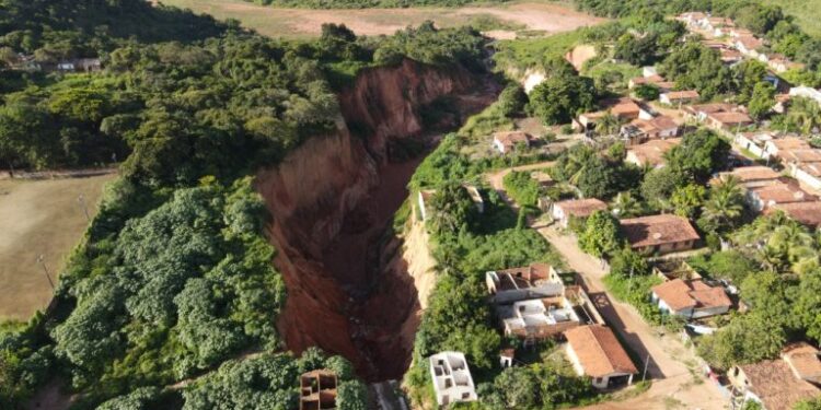
Gullies are ravines that have deepened to the point of reaching the water table. When the water table is reached, there is a potential combination of surface erosion from rainfall and the undermining of slopes caused by the waterlogging of the base and “piping” phenomena, when the exit of groundwater brings with it grains of the soil itself, a process that causes the continuous unloading of the upper horizons.
Gullies evolve upwards with great energy and speed, and can reach depths of several tens of meters and widths of up to hundreds of meters. Rural areas and Brazilian cities that, in addition, are based on more sandy, less clayey soils, and therefore more erodible, are witnesses to the enormous destructive power of gullies. Due to their genesis, they are always associated with some human intervention that has led to a concentrated runoff of surface water. Both agricultural and livestock activities, as well as urban expansions, such as the implementation of engineering works, for example the network of local and rural roads, are prodigious in causing concentrated runoff of surface water if due technical care is not taken. It is this concentration of surface water runoff that, thrown onto unprotected slopes, will open the first furrows and deepen them until they become immense gullies.
Based on the perfect knowledge of their formation dynamics, technical recommendations for preventing and correcting gullies in both rural and urban areas have emerged clearly and naturally in the technical community. Several alternatives are available to achieve these objectives; discussing them is not within the scope of this article, but a first-order conceptual guideline can be pointed out here: concentrated water runoff produced by some type of human action, if it is impossible to avoid it, cannot be released directly onto unprotected land. It must be conducted through masonry structures, ducts, water ladders, hydraulic energy dissipators, etc., to the nearest natural watercourse or lake, or special infiltration structures (the water table is grateful). In the case of stabilizing an already developed gully, the first essential measure is precisely to prevent concentrated surface water from continuing to flow into its main “headwater” and the “headwaters” of its possible (and common) branches. As for the interior of the gully, the essential measure is to prevent the water from the water table and the rainwater that still falls there from continuing to transport the soil downstream. To this end, self-draining transverse structures/barriers (for example, gabion dikes) are essential, as many as necessary, to retain any material that may be transported and allow the water to drain freely. These structures should not be rigid (concrete), since they will undergo some natural adjustment and, if rigid, will suffer compromising damage. Once these two processes, the external and the internal, are interrupted, the gully will tend to a natural stabilization process, which will evolve towards the vegetation recovery of the affected land. Obviously, man can greatly accelerate this vegetation recovery.
It should be noted, however, that a gully “bleeds” and lowers, at least locally, the water table, which, in addition to being a huge waste of good groundwater, can cause serious geotechnical problems. This condition recommends that, whenever possible, gullies should be stabilized by filling them with soil or inert debris without bottom drains, which will allow the original topography to be restored and the natural levels of the water table to be restored.
The choice of urban recovery method for a gully will depend on its depth and size, based on a simple cost-benefit analysis. A very large gully, tens of meters deep and with several branches, should be restored by lowering its natural slopes and by intensive reforestation, which would allow it to be transformed into a leisure and sports park in the urban area, for example. Smaller gullies can be restored by filling them in, allowing for the installation of public squares, playgrounds, or more elaborate urban facilities such as sports courts, for example. Under no circumstances should a gully be used (as is unfortunately common) to dispose of urban waste or environmentally harmful industrial waste. This absurdity means direct contamination of surface and groundwater.
There are currently tens of thousands of active gullies in Brazil. An immediate and widespread stabilization program would be financially impractical today. However, in terms of preventive care, there is a whole arsenal of technical measures (rural and urban) to stop the “production” of new gullies. Another arsenal of the same kind allows for the implementation of a gradual stabilization program and environmental recovery of those that are already in place. The financial, social and property costs of the current inaction are too exorbitant for public and private authorities to continue to ignore this geological tragedy, a sad cultural mark of the occupation of the national territory.
Author: Álvaro Rodrigues dos Santos is a geologist, former director of Planning and Management at the Institute of Technological Research (IPT) and author of the books “Engineering Geology: Concepts, Method and Practice”, “The Great Barrier of Serra do Mar”, “Geological Dialogues”, “Cubatão”, “Floods and Landslides: Causes and Solutions”, “Basic Manual for the preparation and use of the Geotechnical Map”, “Cities and Geology”
Author’s email: santosalvaro@uol.com.br
*Boçoroca or Voçoroca are terms that refer to the same geological phenomenon, which consists of the formation of large erosion holes. The word comes from the Tupi-Guarani yby-soroc, which means “torn land”
Article originally published in Jornal GGN